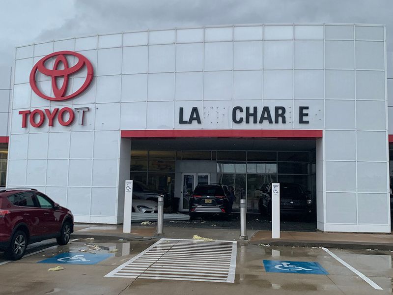
Louisiana auto dealers woke up to the devastation that Hurricane Laura left behind after making landfall overnight.
Laura hit Cameron, La., at 1 a.m. Thursday as a Category 4 hurricane. It was later downgraded and, as of midday, was listed as a Category 1 hurricane. Major damage was visible throughout southern Louisiana.
About 609,000 homes and businesses were without power in three states, The Weather Channel reported. So far, one death attributed to the storm has been reported.
Will Green, president of Louisiana Automobile Dealers Association, said in an email that many of his members closed their dealerships Wednesday and Thursday as the storm continues to make its way up the state.
“Many I have talked to have lost power and have damage to their buildings, especially those in the Lake Charles area,” he said.
The Louisiana Independent Auto Dealers Association said it is still waiting to hear from dealers in the impacted areas. Typically, it takes dealer associations several hours to quantify the damage from such widespread disasters.
Attempts by Automotive News to reach several Lake Charles area dealerships were unsuccessful on Thursday.
Dealers earlier this week moved inventory and blocked windows in preparation for Hurricane Laura, which had sustained winds of 150 mph overnight.
Less than 50 miles north of landfall, Louisiana dealer Phillip Tarver hunkered down with 30 people in his Lake Charles Toyota dealership Wednesday night.
“The interior of our building held firm and strong, and we didn’t ever feel threatened or in danger,” he told Automotive News early Thursday.
Tarver was assessing damage to the store and his home this morning.
“The building took a good beating but it’s still standing strong, it’s amazing,” he said.
Laura is the first hurricane to hit Louisiana as a Category 4 storm since 1965. According to the National Hurricane Center, Laura is moving northward over southwestern Louisiana at 15 mph with a 60-mile reach from the center of the storm. It is expected to maintain that speed throughout Thursday and into Friday.
As Laura progresses inland, some watches and warnings have been discontinued, but the hurricane warning for High Island, Texas, to Intracoastal City, La., and the tropical storm warning for east of Intracoastal City, La., to the mouth of the Mississippi River remain in effect.
“Hurricane conditions are expected in the hurricane warning area through the morning, with catastrophic wind damage expected near Laura’s eyewall,” the National Hurricane Center said.
The storm is forecast to move across Louisiana on Thursday morning and move northeast through Arkansas, the mid-Mississippi Valley and mid-Atlantic states by Saturday.
Bloomberg reported early Thursday that Laura could inflict more than $15 billion in insured losses.
Texas dealers also were bracing for the storm this week.
Dealer Bryan Case told Automotive News on Thursday morning that his Beaumont store has minimal damage from the hurricane.
“The storm made landfall a little bit more to the east from us than what it was initially projected to and consequently we were spared.”
On Wednesday, Houston-based Group 1 Automotive Inc. said it closed its six stores in the Beaumont, Texas, area and “evacuated as instructed” ahead of Hurricane Laura’s expected landfall on the Gulf Coast.
CarMax said in an email it is closing its locations in Lafayette and Shreveport, La., so it has “time to take necessary precautions.” The used-vehicle retailer said it also plans to close some of its Texas locations early Wednesday evening in response to local guidance. The company will reassess the status of the Texas stores Thursday morning.
“Life-threatening storm surge continues along much of the Louisiana coastline,” the National Hurricane Center said.
The highest storm surge could reach record levels of up to 20 feet from Johnson Bayou, La., to Rockefeller Wildlife Refuge, the National Hurricane Center said. The surge is predicted to impact up to 40 miles inland from the coastline.
Wednesday night the National Hurricane Center warned that the “unsurvivable storm surge with large and destructive waves will cause catastrophic damage from Sea Rim State Park, Texas, to Intracoastal City, La., including Calcasieu and Sabine Lakes.”
The deepest water will occur along the immediate coast near and to the right of the landfall location, where the surge will be accompanied by large and destructive waves.
Surge warnings remain in effect for High Island, Texas, to the mouth of the Mississippi River, according to a Thursday morning public advisory from the National Hurricane Center.
“Rapid weakening is forecast, and Laura is expected to become a tropical storm later today,” the National Hurricane Center said.
The Weather Channel anticipates a heavy rain threat through the weekend from southeastern Texas and southwestern Louisiana up through the central Appalachians as the storm moves northeastward.
In parts of Louisiana, Arkansas and Mississippi, the National Hurricane Center is predicting up to 12 inches of rain, which “may lead to flash and urban flooding and rapid rises on small streams.”
Tornadoes are also possible throughout the day Thursday in Louisiana, Arkansas and Mississippi.
David Muller contributed to this report.